🇲🇬Country
Madagascar in three places: limestone at Bemaraha, the baobab alley near Morondava and the royal hill of Ambohimanga
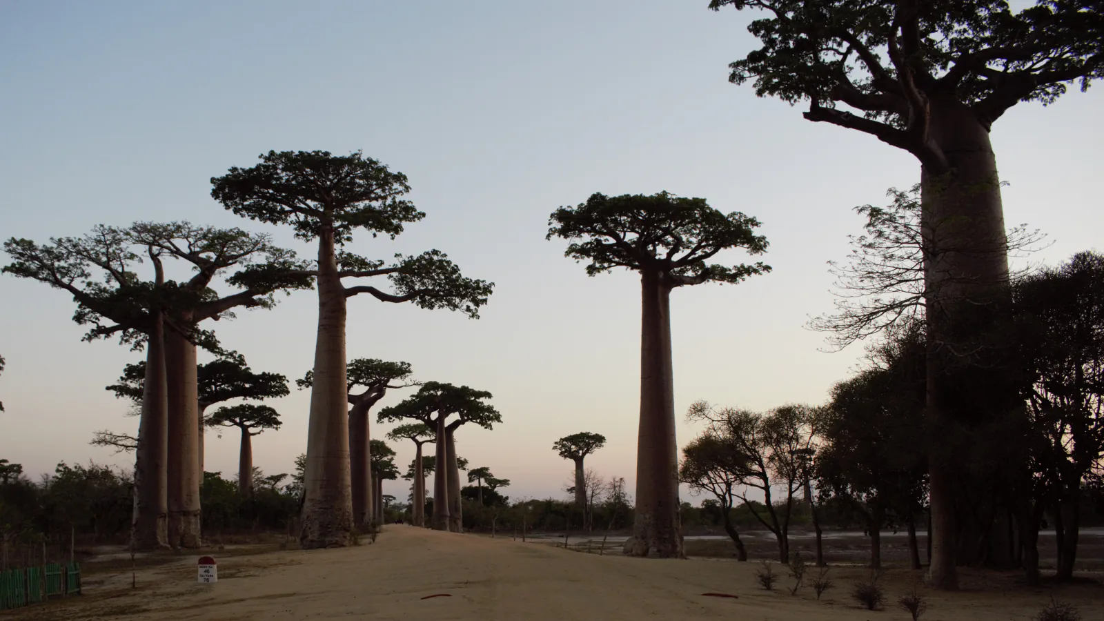
Limestone grikes that began as caves, a baobab road protected by decree and a hill with fourteen stone gateways: the Tsingy de Bemaraha in Melaky Region, the Allée des Baobabs in Menabe Region and the Royal Hill of Ambohimanga in the central highlands. Two lie in the west and one inland, so together they do not stand for the whole island.
At a glance
A place worth remembering
Tsingy de Bemaraha: grikes that began as caves
The IUGS geoheritage entry places the Tsingy de Bemaraha in Melaky Region, on a Middle Jurassic (Bajocian–Bathonian) limestone sequence 300–500 m thick, crossed by the Manambolo river, which has eroded a canyon 300 m deep. UNESCO describes limestone pinnacles rising up to 100 m and now lists the reserve, which has since become a national park, as one of six component parts of the Andrefana Dry Forests; it also names Melaky, where Bemaraha lies, among the western centres of endemism that it describes as the interfluves of Madagascar’s great rivers. Veress and colleagues surveyed profiles and measured grike directions at Bemaraha (International Journal of Speleology, 2008). The study describes the tsingy as built up of giant grikes, fissures developed along cracks, and of much smaller karren features between them; the authors conclude that most grikes were created from caves that formed under the karst water table and were later opened up to the surface, probably by downward-progressing dissolution or by the collapse of cave roofs. In their reading, much of this forest of sharp stones began underground.[2][1][3]
Allée des Baobabs: a protected area with a 1.68-hectare core
Decree No. 2015-760 of 28 April 2015 created the protected area named “Allée des Baobabs” in Morondava District, Menabe Region; its annexes name the rural commune of Bemanonga and give the core zone (“noyau dur”) at Bekonazy Centre as 1.68 ha of dry forest. In a 2023 announcement the Fondation pour les Aires Protégées et la Biodiversité de Madagascar (FAPBM) lists it as the Natural Monument Allée des Baobabs, Category III, with Adansonia grandidieri as the conservation target, and names it among four protected areas in a baobab-forest project funded by the Danish Hempel Foundation (DKK 15 million, 2022–2025) and implemented by a consortium of Madagascar National Parks, Fanamby and Durrell. Fieldwork on the species in Menabe (Andriafidison and colleagues, 2019) used 103 transects of 1 km in the Mahabo, Manja and Morondava districts and found that 54.0% of Grandidier’s baobabs had been subject to bark extraction; the authors estimate that about 9,800 trees were affected over ten months of market monitoring and recommend planting young baobabs and promoting alternatives to baobab ropes. A 2024 study of seed dispersal recorded a native rodent, Eliurus myoxinus, handling fruits and seeds on the ground and found seeds in bush pig faeces; germination of dispersed seeds was low, but their chance of producing viable seedlings was higher than that of seeds left under adult trees.[4][5][6][7]
Ambohimanga: a hill with fourteen stone gateways
UNESCO describes a fortified hill in the central highlands, in Imerina, the region of Antananarivo: a system of ditches with fourteen fortified stone gateways, and a royal city with two palaces, a small pavilion, an “ox pit”, two sacred basins and four royal tombs. The property covers 59 ha with a 425 ha buffer zone and remains a place of worship. UNESCO also records its recent history: the sacred wooden houses that symbolise the royal tombs, which it says were demolished by the French colonial authorities, were rebuilt by the Malagasy State in 2008 with traditional materials and according to the rites, and the remains of the sovereigns removed in 1897 have been placed back in their original tombs. The forest on the hill holds endemic and medicinal species, and UNESCO names the abundance of zahana (Phyllarthron madagascariensis) as part of its specific character.[8]
Good to know
A few clear answers before you explore.
How did the tsingy of Bemaraha form?
A 2008 study that surveyed profiles and measured grike directions at Bemaraha concludes that most grikes were created from caves formed under the karst water table and later opened up to the surface, probably by downward-progressing dissolution or the collapse of cave roofs. The limestone itself belongs to a Middle Jurassic (Bajocian–Bathonian) sequence 300–500 m thick, according to the IUGS geoheritage entry.[3][2]
What protection does the Allée des Baobabs have?
Decree No. 2015-760 of 28 April 2015 created a protected area named “Allée des Baobabs” in Morondava District, Menabe Region, and its annexes list the core zone at Bekonazy Centre as 1.68 ha of dry forest. FAPBM lists it as a Natural Monument, Category III, with Adansonia grandidieri as the conservation target. A 2019 study of the species in Menabe warned that populations without protected status may disappear locally if bark extraction intensifies in accessible sites.[4][5][6]
What does the Royal Hill of Ambohimanga consist of?
According to UNESCO it combines a fortification system of ditches and fourteen fortified stone gateways, a royal city with two palaces, a small pavilion, an “ox pit”, two sacred basins and four royal tombs, sacred places and agricultural land, together with remnants of forest on the hill. The property covers 59 ha, with a buffer zone of 425 ha.[8]
The WorldStamped community
Every visit becomes part of a story.
- Members with public visits
- 0
- Places with public visits or memories
- 0
- Public memories
- 0
No public visits have been counted here yet. Add this destination to your own map and choose what you want to share.
Members are counted once. Counts include only eligible public activity from profiles that allow search discovery. Private and followers-only content is excluded.