🇳🇴Country
Norway: rock carvings, a Hanseatic wharf and a surveyed meridian
Prehistoric carvings above Alta Fjord, a Hanseatic trading wharf in Bergen and the northern end of a survey chain that runs 2,820 km to the Black Sea are UNESCO World Heritage properties that show Norway on very different timescales.
At a glance
A place worth remembering
Alta: carved at the shoreline, now high above it
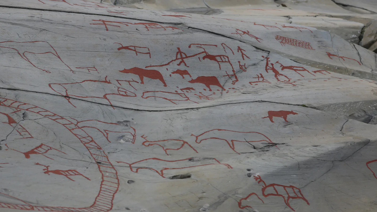
The Rock Art of Alta lies at the head of Alta Fjord, far north of the Arctic Circle. UNESCO counts thousands of carvings and paintings at 45 sites in five areas, and explains that the oldest carvings stand at the highest points because the land has risen since the Ice Age. At Hjemmeluft, the largest area, Alta Museum places the carvings 8–25 metres above today’s sea level, although they were first cut at the water’s edge. UNESCO says Hjemmeluft is the only one of the five areas open to the public, and that some carvings beside its walkways have been painted red to make them easier to see, a practice it notes is debated because it affects authenticity.[1][2]
Bryggen, Bergen’s wharf rebuilt on its own plan
Bryggen is the old harbour district of Bergen. The Hanseatic League opened an office there in 1350. It was one of four such offices in northern Europe, and UNESCO and the City of Bergen both record that Bergen’s is the only one whose buildings still stand. Fires repeatedly destroyed the wooden rows, and each time they were rebuilt on the earlier property plan with traditional methods; today’s appearance dates from after the fire of 1702. About 62 buildings remain, set in narrow rows with gabled ends towards the harbour and passages between them. Bryggen was inscribed in 1979.[3][4]
Where the Struve Arc starts at Hammerfest
The Struve Geodetic Arc is a chain of survey triangulations 2,820 km long that crosses ten countries between Hammerfest and the Black Sea. It was measured between 1816 and 1855 under the astronomer Friedrich Georg Wilhelm Struve and produced the first accurate measurement of a long segment of a meridian. Four of the 34 inscribed station points are in Norway: Fuglenes at Hammerfest, Lille Raipas at Alta and two in Kautokeino. The Norwegian measurements were made from 1845 to 1850 by two military surveyors and one scientist over four summer seasons. A Meridian Statue in Hammerfest marks the Norwegian end, and the arc was inscribed in 2005.[5][6]
Good to know
A few clear answers before you explore.
Why are the Alta carvings so far above the sea?
They were cut at the shoreline in prehistoric times, and the land has risen since the Ice Age. The oldest carvings therefore stand highest; at Hjemmeluft, Alta Museum gives 8–25 metres above today’s sea level.[1][2]
Who traded at the Bryggen wharf?
German merchants of the Hanseatic League, who set up their Bergen office in 1350. Through privileges granted by the Crown they controlled the trade in stockfish from Northern Norway, with offices and living quarters at the front of each row and fireproof stone storerooms at the back.[3]
Where in Norway does the Struve Arc begin?
At Fuglenes by Hammerfest, near the Arctic Ocean, from where the chain of survey points runs to the Black Sea. The Meridian Statue in Hammerfest marks the Norwegian end.[5][6]
The WorldStamped community
Every visit becomes part of a story.
- Members with public visits
- 0
- Places with public visits or memories
- 0
- Public memories
- 0
No public visits have been counted here yet. Add this destination to your own map and choose what you want to share.
Members are counted once. Counts include only eligible public activity from profiles that allow search discovery. Private and followers-only content is excluded.