🇱🇧Country
Lebanon: stone left in the Baalbek quarry, cedars above the Qadisha Valley and the sand bridge at Tyre
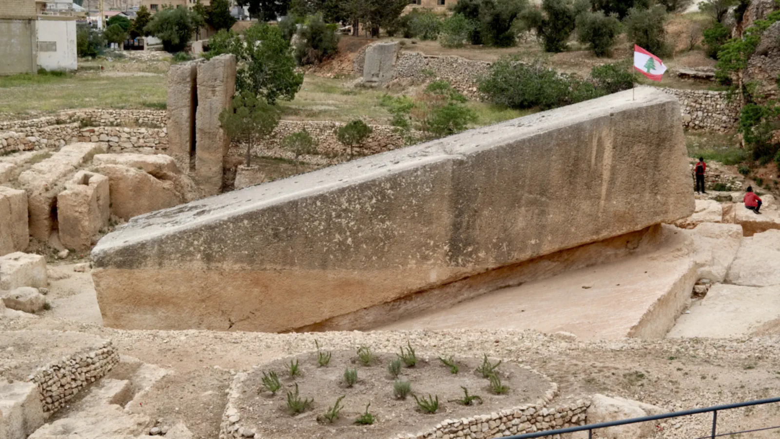
At Baalbek, a crack and an internal karst zone may explain why one giant block remained attached; Qadisha pairs hermit caves with an upland cedar forest, while a submerged sand spit shaped Tyre’s coast.
At a glance
- Hajjar al-Hibla
- Cut to 19.6 × 4.2 × 4.8–5 m, but left attached to bedrock in the Baalbek quarry.[2]
- Cedars of God
- On Mount Makmel at 1,900–2,050 m; a 2001 survey recorded 15 fragmented cedar stands in Lebanon.[5][6]
- Tyre’s causeway
- The 2007 sediment study places a proto-tombolo 1–2 m from mean sea level before the causeway was built.[8]
A place worth remembering
Baalbek: why one quarry block stayed attached
Qadisha and the Cedars of God: caves and an upland forest
UNESCO groups the Qadisha Valley and the Forest of the Cedars of God in one property; the forest itself stands on Mount Makmel, east of Bcharré, at 1,900–2,050 m. In Qadisha, hermitages occupy natural caves, some with frescoes, while several grain terraces remain cultivated. The Royal Botanic Garden Edinburgh places Cedrus libani mainly on north- and west-facing slopes from 1,300 to 3,000 m. For Lebanon it cites Talhouk (2001): 15 fragmented stands, over half of them occupying less than 1 km² and severely degraded.[5][6]
Tyre: a causeway built over a near-surface sand spit
UNESCO says ancient Tyre was built mostly on an island, now called the “former island”, and that Alexander blocked the straits with a dike. From sediment cores, a 2007 study reconstructs a shallow natural proto-tombolo already present by Alexander’s time; it argues that the causeway later transformed the coastal system. The authors place the spit 1–2 m from mean sea level and identify sediment from the Litani delta, with sandstone reefs sheltering water behind the island.[7][8]
Good to know
A few clear answers before you explore.
Why was Hajjar al-Hibla left in the quarry?
The DAI’s 2014 investigation found a large karst area inside the stone and a long crack. The authors say the block probably would not have reached the temple without damage.[2][3]
Where does Lebanon’s cedar forest stand?
It stands on Mount Makmel, east of Bcharré, at 1,900–2,050 m. UNESCO includes it in the property that also covers the Qadisha Valley.[5]
What landform was present before the causeway at Tyre?
The 2007 sediment study places a submerged proto-tombolo (a sand spit) 1–2 m from mean sea level before construction. It argues that the causeway later reshaped the coast and helped the spit grow into the present isthmus.[8]
The WorldStamped community
Every visit becomes part of a story.
- Members with public visits
- 0
- Places with public visits or memories
- 0
- Public memories
- 0
No public visits have been counted here yet. Add this destination to your own map and choose what you want to share.
Members are counted once. Counts include only eligible public activity from profiles that allow search discovery. Private and followers-only content is excluded.