🇭🇳Country
Honduras: a stairway rebuilt from blocks, a river basin and a reef survey
At Copán, archaeologists found only the lower 15 of 63 stairway steps in their original positions; the rest was rebuilt from fallen blocks in 1937–1940. In the Mosquitia, Río Plátano’s 350,000-ha reserve reaches from mountain headwaters to the Caribbean mouth. A 2024 regional report card includes 99 sites around Honduras’s reefs.
At a glance
A place worth remembering
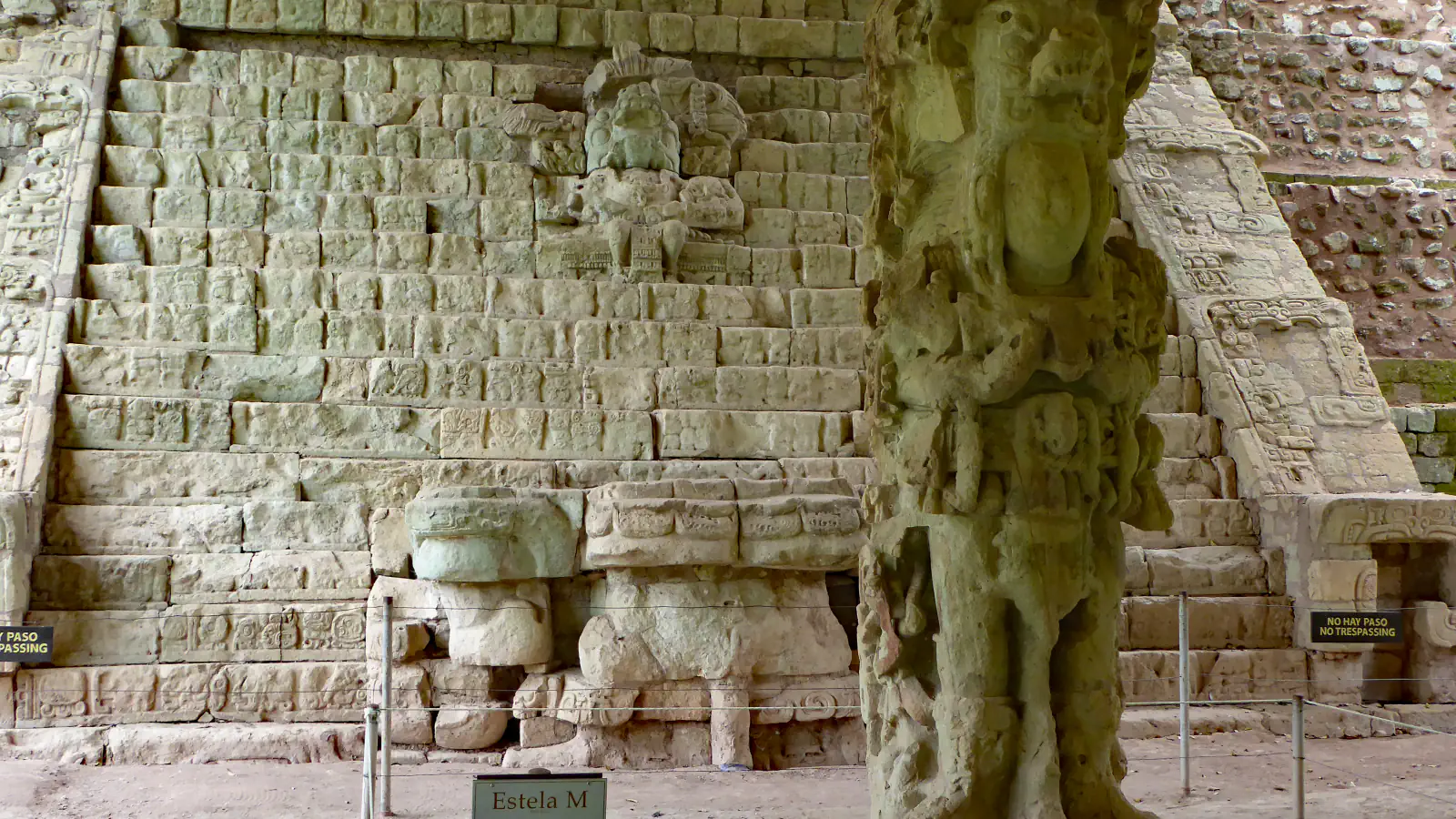
Copán: a stone text put back together
The Copán stairway’s carved text spans four centuries of dynastic history, so its legibility is central to conserving the monument. From 1999 to 2005, Getty and Honduras’s IHAH digitally documented the blocks, monitored temperature and moisture around the stone, and tested surface treatments. This work followed a reconstruction in 1937–1940: excavation found only the lower 15 of 63 steps in their original positions; the rest was reassembled from original blocks recovered on the plaza. UNESCO notes that some original monuments at the site have also been moved to the Sculpture Museum and replaced with replicas.[1][2]
Río Plátano: one river basin, protected from source to sea
UNESCO describes the Río Plátano Biosphere Reserve in northeastern Honduras’s Mosquitia as 350,000 ha protecting the whole watershed, from mountain headwaters to the Caribbean outlet. Its forested uplands reach 1,418 m at Punta Piedra; nearer the coast, the river meanders for about 45 km through lowlands, and along the coast lie Laguna Brus and Laguna Ibans. The account also describes a forest gorge where boulders conceal the river at a cataract. Archaeological protection came first: Ciudad Blanca Archaeological Reserve was established in 1960, then its status changed to Archaeological National Park in 1969, a designation UNESCO says Río Plátano formally retains. The biosphere reserve followed in 1980 and was substantially enlarged in 1997. UNESCO lists Pech, Tawahka, Miskito and Garífuna communities, as well as Mestizo (Ladino) residents, in and around the reserve. The property has been on the World Heritage in Danger list since 2011.[3]
Reefs of Honduras: a count of 99 sites
The 2024 Mesoamerican Reef Health Report Card by Healthy Reefs for Healthy People covers 286 sites across Mexico, Belize, Guatemala and Honduras. Its Honduran map names subregions that include Utila, Roatán, Guanaja, Cayos Cochinos and the west and east coasts. Of that Honduras sample, the report grades 5% good, 28% fair, 40% poor and 27% critical. Contributors included Roatan Marine Park, Bay Island Conservation Association and Fundación Cayos Cochinos. Across its regional sample, the report attributes an increase mainly to higher herbivorous-fish biomass; it still rates overall reef health as poor.[4]
Good to know
A few clear answers before you explore.
How much of Copán’s Hieroglyphic Stairway was in place when it was excavated?
Only the lower 15 of the stairway’s 63 steps remained in their original positions at excavation. The 1937–1940 reconstruction used original carved stones recovered from the plaza; Getty’s later conservation work focused on keeping the four-century dynastic text legible.[1]
What does the Río Plátano reserve protect?
UNESCO says the reserve encompasses Río Plátano’s watershed from its mountain sources to the Caribbean river mouth, across 350,000 ha in the Mosquitia. Within that span are upland forest, savannah, wetlands and coastal lagoons; the river is described as flowing freely to the sea.[3]
Who surveys Honduras’s reefs, and what did the 2024 survey find?
Healthy Reefs for Healthy People’s 2024 report card uses data from 99 Honduran sites, gathered with partners including Roatan Marine Park, the Bay Island Conservation Association and Fundación Cayos Cochinos. In that country sample, 5% were rated good, 28% fair, 40% poor and 27% critical.[4]
The WorldStamped community
Every visit becomes part of a story.
- Members with public visits
- 0
- Places with public visits or memories
- 0
- Public memories
- 0
No public visits have been counted here yet. Add this destination to your own map and choose what you want to share.
Members are counted once. Counts include only eligible public activity from profiles that allow search discovery. Private and followers-only content is excluded.