🇧🇩Country
Bangladesh: Sundarbans, Paharpur and Jamdani
The Sundarbans study compares tree growth across two salinity zones; at Paharpur, 177 monastic cells encircle a terraced shrine, and Jamdani motifs form during weaving in Narayanganj.
At a glance
- Sundarbans
- Mean annual ring width in the study: 1.17 ± 0.16 mm in the sampled lower-salinity eastern zone and 0.93 ± 0.15 mm in the more saline western zone (PLoS ONE, 2016)[2]
- Paharpur
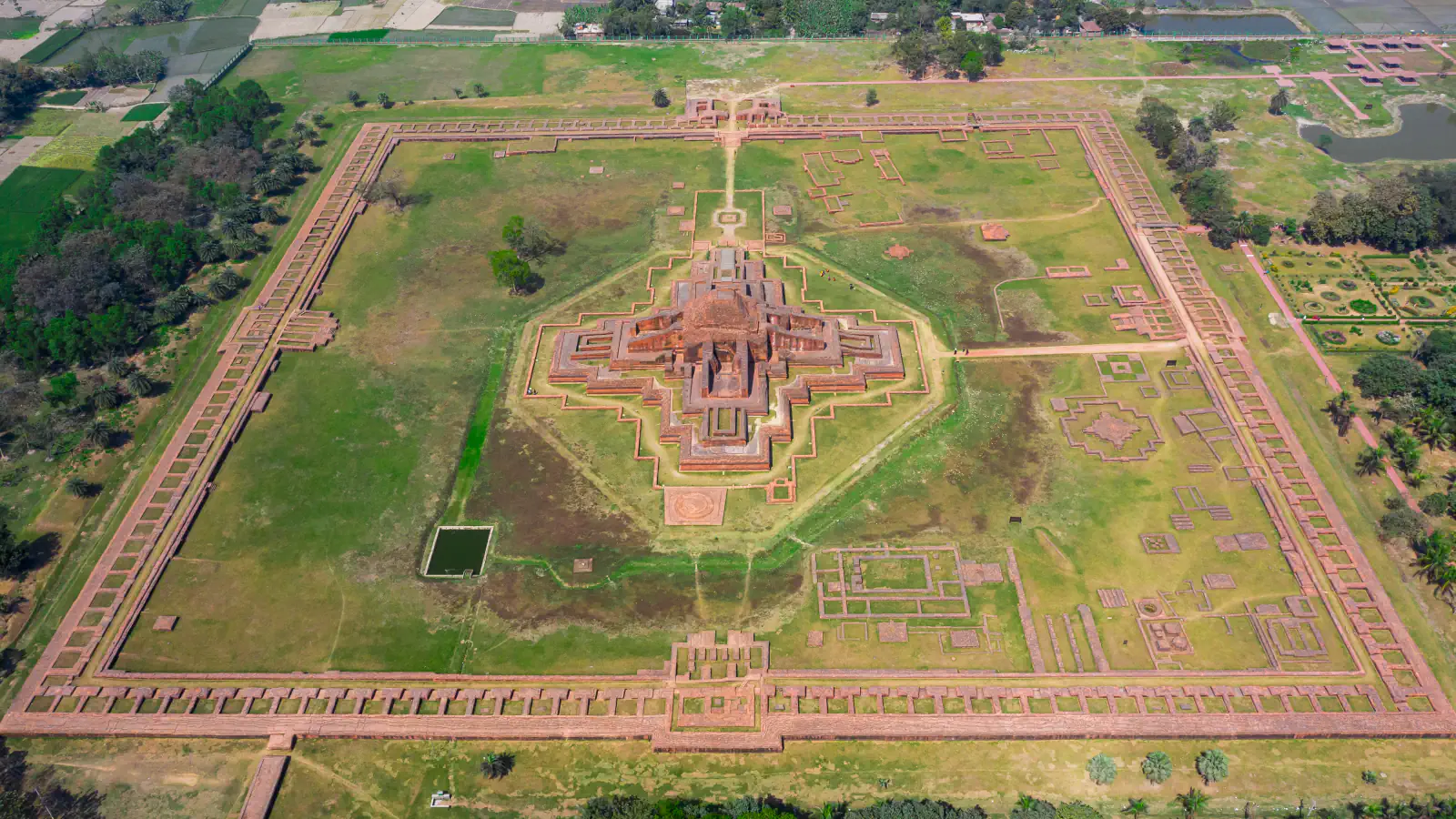
- 177 cells in the final phase; the central shrine rises through three terraces to about 70 feet (21 m)[3][4]
- Jamdani
- ICHCAP’s record for the element inscribed by UNESCO in 2013 lists Rupshi (Rupganj), Sonargaon and Siddhirganj in Narayanganj District[7]
A place worth remembering
Tree rings and rainfall in the Sundarbans
The 2016 study links tree-ring growth with conditions across eight Sundarbans sites. It analysed 40 Heritiera fomes stem discs: mean annual ring width was greater in the lower-salinity east (1.17 ± 0.16 mm) than in the west (0.93 ± 0.15 mm). Table 1 reports higher soil ECe at western sites (35–42 dS/m) than at eastern ones (16–21 dS/m). The authors found the closest growth links with annual and monsoon rainfall.[2]
Paharpur: a square of cells around a cross-shaped shrine
At Somapura Mahavihara in Paharpur, the monastery’s outer boundary is a square of monastic cells opening onto an inner courtyard, in which stands a cruciform central shrine. UNESCO describes the shrine as climbing in three terraces to roughly 70 feet (21 m). UNESCO links the monastery’s construction with Dharmapala Vikramshila, citing a clay seal found in the compound.[3][4]
Jamdani: patterns woven in on the loom in Narayanganj
Jamdani is a sheer cotton fabric whose patterns take shape through a discontinuous-weft process. ICHCAP’s record for the element inscribed by UNESCO in 2013 lists Rupshi, Sonargaon and Siddhirganj in Narayanganj District, near the Shitalakshya River. Banglapedia describes two weavers working side by side at one loom, with a heavier yarn for the motifs so that they stand proud of the ground cloth.[7][5][6]
Good to know
A few clear answers before you explore.
Where are the Sundarbans in Bangladesh?
The UNESCO-listed Sundarbans Reserve Forest lies in Bangladesh’s south-west, on the delta of the Ganges, Brahmaputra and Meghna rivers.[1]
Are Jamdani motifs embroidered onto the finished cloth?
No. The ICHCAP record describes motifs as taking shape while the cloth is being woven, rather than as decoration added to a finished fabric.[7]
How many cells were on each side of the monastery?
In the 177-cell final phase, the north side had 45 cells; the east, south and west sides had 44 apiece, according to Banglapedia.[3][4]
The WorldStamped community
Every visit becomes part of a story.
- Members with public visits
- 0
- Places with public visits or memories
- 0
- Public memories
- 0
No public visits have been counted here yet. Add this destination to your own map and choose what you want to share.
Members are counted once. Counts include only eligible public activity from profiles that allow search discovery. Private and followers-only content is excluded.